Any day now the translation of the Reports will come out of the printing press. Before this happens, however, we present another entry related to this release.
This time we will refer to a fragment of the News of the Royal Board of Reconstruction of the Castle in Malbork in West Prussia (Nachrichten der Königlichen Schloßbauverwaltung zu Marienburg Westpr.). These additional reports were prepared by the head of the Castle Reconstruction Board, Conrad Steinbrecht (then Bernhard Schmid), while the Society’s reports were always edited by its current chairman. Messages from 1911 were attached as an appendix to the Reports. However, they were not a permanent element. Steinbrecht’s texts, as their author was the person most knowledgeable in all matters and processes related to the reconstruction of the castle, were free from the numerous errors present in the Society’s Reports. The fragment quoted below touches on several interconnecting threads that we will try to discuss. His choice was inspired by the work on the promenade of Maciej Kilarski Boulevard, on the section from the footbridge on the Nogat to the footbridge over the Młynówka, implemented by the City Hall. This urban investment would not have been possible without the sequence of events described in the report, same as a comfortable walk along the banks of the Nogat from the Old Town to the Buttermilk Tower, which has only been possible for about 100 years.
News of the Royal Board for the Reconstruction of the Castle in Malbork in West Prussia about the activities in the years of construction 1912 to 1916 submitted to the General Assembly of the Society for the Reconstruction and Beautification of the Malbork Castle held in the fall of 1916 (page 9):
[…] Also, the Outer Bailey will not avoid being reconstructed in the future. It is still in private possession, like a foreign body, in the state territory of the Castle, and after the Nogat has been regulated, it remains burdened with incompatible buildings. In the years 1911–1912, there was an opportunity to buy out its main plots. In general, the regulation of Nogat will have significant impact on the coastal side of the Castle. In front of the Castle there will be no more rapid flooding or dangerous ice floes. However, the pathetic summer image of the “deserted” Nogat and its neglected, dirty shore remained. On the wide water surface which is the foreground [in the western panorama ˗ B.B.], a lively water sport will develop, and in the future perhaps also more lively ship traffic. The homogeneous [with the castle section – B.B.] development of the quay at the level of urban buildings is impeded by ownership relations, perhaps without detriment to the picturesque view. The city is planning, however, [a construction of ˗ B.B.] the coastal square and the promenade in the castle section, where ownership belongs to the state. This will attract various activities, which will improve the image of the Castle and the city. The urban section towards the Market Square looks unfavorable, there is no possibility of adopting satisfactory solutions […].
In 1900 it was decided to regulate the Nogat. Work on the construction of the floodgates system began in August 1912 and was completed in 1915. As a result, the Nogat was practically cut off from the Vistula’s inflow. Since then, the river flows up to a maximum of 30 m3 / s of water, which is approx. 3% of the average flow before the regulation, i.e. the earlier construction of the canal in Mikoszewo and in the next stage, mentioned in the fragment of the translation, the execution of the floodgates in Michałów, Rakowiec and Szonów . Approximately 87% of the Vistula flow was flowing into the Nogat until these hydrotechnical investments were made.


ILL. 1-2. View of the buildings of the Outskirts of the Castle at the turn of February and March 1889 and in the summer of the same year. The spring and winter congestion completely covered the coastal wall and flooded residential buildings. The photo taken in late spring shows the width of the outer ward before the river regulation; Marienburg Baujahr 1889, ill. 26 and 28.
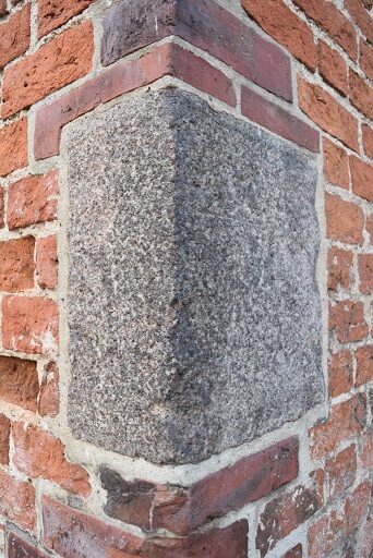
In this way, cyclical, natural, strong inundations and flooding of the castle area were permanently eliminated. The spring high water in Malbork reached really high (Fig. 1–2) and far. The testimony to this are the stone water gauges commemorating and documenting particularly severe and memorable floods (Fig. 3–4). Therefore, it was only a little over a hundred years ago that the castle and the city of Malbork were able to start developing the Nogat waterfront with its permanent infrastructure. Before that, for six hundred years, all coastal facilities had to be mobile and temporary, and the use of the port and the river during the winter-spring months was impossible.
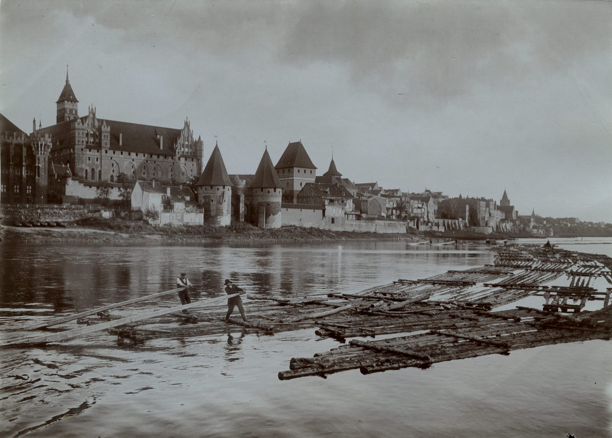
While writing about the pathetic summer image of the river, Steinbrecht noted new, negative effects of the regulation which de facto channeled the Nogat. In the summer of 1916, barges, berlins and rafts disappeared from its surface. In theory, the route allowed for movement of ships with a capacity of 400 tons, 55 meters long, 8 meters wide and a draft of 1.6 meters, but vessels capable of sailing in the new conditions were to appear only in the future, while the rafters who had been passing through Malbork for centuries were gone forever. (Fig. 5).
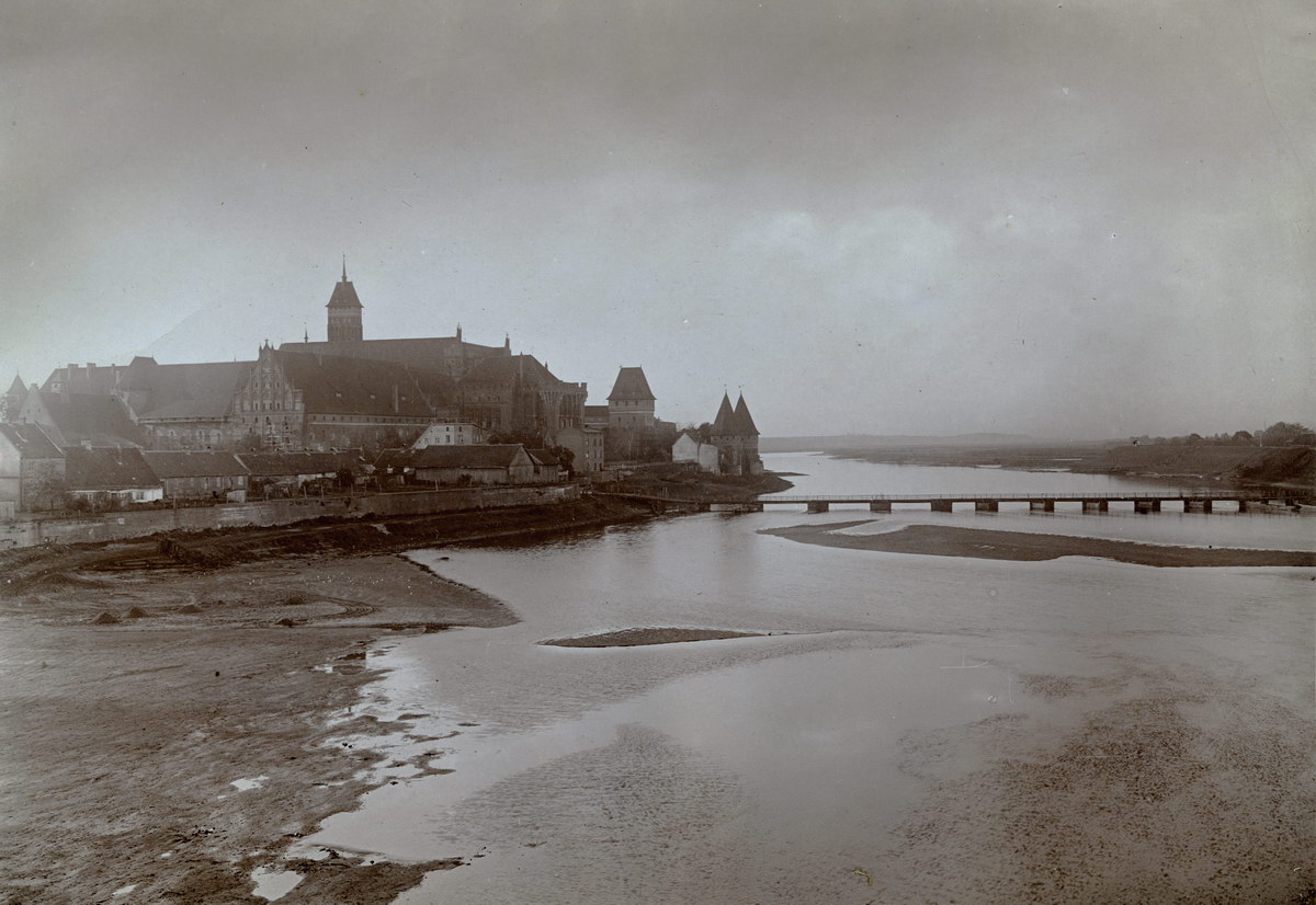
Instead, it was now possible to develop the waterfront (Fig. 6) for recreational purposes. The promenade, in the form known to the post-war inhabitants of Malbork, required coastal land ownership regulation. This, in addition to the successive acquisition of private land from the castle area, which was also reported by Steinbrecht, was an element of the process initiated at that time of unveiling the western facade of the High and Middle Castles and creating its new panorama from the Buttermilk Tower to the Sparrow Tower.
It is worth recalling that the vegetation, including the beautiful trees present in the western landscape of the castle, are also the result of works completed in 1915. Before them, they would have neither such space nor a chance to survive in confrontation with the Nogat current (Fig. 7–8).
(by B. Butryn)

ILL. 3-4. Granite water levels (German: Wasserstad) at the church of St. Lawrence and the northern corner of Karwan, documenting the record flood of March 25, 1888 (photo: B. Butryn).


Il. 5. Flisacy podczas jednego z ostatnich flisów przez Malbork, ok. 1910 rok (MZM/DH/560/1/38).

ILL. 6. The bank of Nogat in the section of the Low Castle, whose aesthetics Steinbrecht complained about, early autumn 1907 (MZM / DH / 560/1/5).

ILL. 7. The high state of the Nogat with a moving ice floe in the winter, around 1900–1905 (MZM / DH / 560/1/54).

ILL. 8. High level of Nogat in the summer, the waters of which flow to the mouth of the castle moat, 1903 (MZM / DH / 560/1/24).
